Digital Groundwater Monitoring System: A Critical Foundation to Inform Natural Resources Management Policy and Sustainable Irrigation Development in Nepal
This blog’s writers are Saral Karki, research associate—data management and analysis, and Rudriksha Rai Parajuli, technical partnerships manager and groundwater team.
In Nepal, government policy focuses on expanding the use of groundwater for irrigation to enhance agricultural productivity. However, this strategy faces several challenges, including a lack of comprehensive data on groundwater resources and appropriate cropping patterns to guide where, and for what, crops groundwater should be tapped for irrigation. Parts of Nepal’s lowlands — the Terai, where agriculture is most intensive — are equipped with groundwater wells. Here, however, inconsistent rainfall and the underuse of these wells have slowed progress toward achieving national policy targets for food self-sufficiency and cereal productivity growth with irrigation. These challenges are expected to increase significantly with climate change.
Over the last three years, the USAID-supported Cereal Systems Initiative for South Asia (CSISA) and the CGIAR Regionally Integrated Initiative Transforming Agrifood Systems in South Asia (TAFSSA) has worked with the Groundwater Resources Development Board (GWRDB), a unit within the Nepal government’s Ministry of Energy, Water Resources and Irrigation (MoEWRI) to develop a comprehensive system to digitally collect groundwater monitoring data and to inform irrigation development in Nepal.
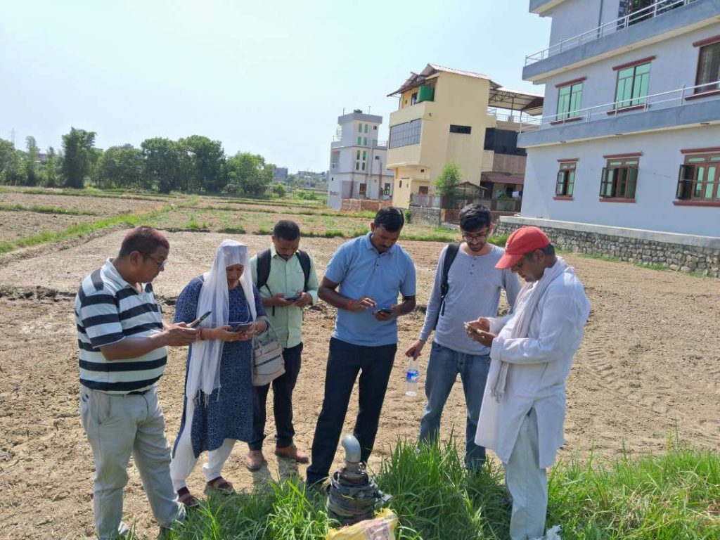
Together, these partners are collaborating to scale out the use of the digital groundwater monitoring system and develop a data dashboard using the government’s existing system of monitoring wells. Users load data onto their mobile phones and tablets, and upload the collected data, which are then e-processed, visualized and made available for free download.
As these data are readily available and provide instant information on the status of groundwater, policymakers and development planners can utilize this information to intensify irrigation sustainably. This also helps to detect unsustainable groundwater use in the locations. The dashboard ensures efficiency in data accessibility and sharing, and anybody needing the data is redirected to the dashboard.
Figure 2: Manoj Khatiwada, senior hydrogeologist, GWRDB office in Banke. August 14, 2023. Photo Credit: Nabin Maharjan, CIMMYT.Mr. Manoj Khatiwada, senior hydrogeologist and head of the GWRDB office in Banke district, credited the digital groundwater monitoring system as having more robust and reliable data than the paper-based system used in the past. He added, “With the paper-based system we used to have, we had no way of tracking if the well observer went to the wells, but with the GPS parameters included in the digital form, we can track whether the observer did the in-situ data collection.” He explained that this system facilitates data collection efforts for well observers, who are freed up from worrying about data management issues, such as losing the paper-based monitoring logbook. Mr. Khatiwada also predicted increased use of data, and that the dashboard would be easily accessed and used by local, provincial and national government institutions involved in irrigation planning. He expects USAID’s implementing partners and other development organizations to use the data to design water-related programs.
The system presents a graphical representation of groundwater levels and enables time-bound comparisons between shallow tube wells and deep tube wells, while visually assessing whether water levels are depleting, increasing or stable (Figure 3).
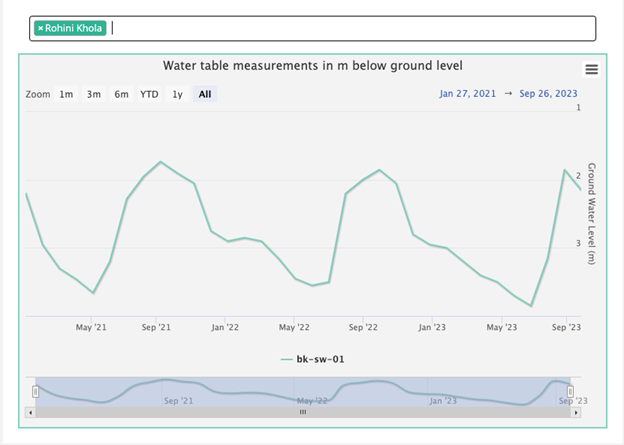
Dashboard users can easily understand the distinct seasonal pattern in the monitored wells — consistent groundwater depletion during the dry season, followed by a rise with the onset of the monsoon rains. Where groundwater cannot sufficiently recharge during the monsoon season, irrigation development planners may risk undermining long-term sustainability, mainly if they promote water-consumptive crops in new irrigation schemes.
The data presents water levels in the community and can be used by municipal and community-level engineers planning to install drinking water hand pumps. Furthermore, data can be used to identify the type of pumps suitable for the geographic region, based on the water levels identified as part of monitoring. Scientific researchers also now have access to this unique dataset, which can be used to make future predictions about water availability resulting from the impacts of climate change.
On February 26, 2023, the CSISA and GWRDB teams held a progress update meeting, at which Dr. Anton Urfels/CSISA handed over digital devices/tablets to the executive director of GWRDB, Mr. Bishnu Belbase. These are being used for data collection, which has significantly improved as a result, with GWRDB now collecting data from 137 groundwater wells, compared to 53 groundwater wells in the pilot phase. Participants also decided to prepare a “guideline for groundwater monitoring and extraction” and get the Nepal government to endorse it as a policy document. The guideline will serve as a toolkit for groundwater monitoring, facilitating users to make rational decisions on sustainable extraction and the use of groundwater. A joint team from CSISA, MoEWRI and GWRDB have started drafting the guideline, to complete it by March 2024 and get it endorsed by June 2024.
Similarly, on October 11, 2023, CSISA and GWRDB jointly organized a “Groundwater Monitoring Data Sharing Platform Dissemination [with] Stakeholders” event in Kathmandu. Mr. Gopal Prasad Sigdel, secretary of the MoEWRI, expressed his appreciation for the initiative. He emphasized the importance of a dashboard for data accessibility and the need to expand its utilization.

The digital monitoring system is slowly gathering momentum and now includes monitoring the location of the wells in most of the Feed the Future districts in Nepal (Figure 5). The data collection and training are an ongoing effort in the scaling process. Furthermore, various other governmental stakeholders, mainly the Department of Water Resources and Irrigation (DWRI) and Water Resources Research and Development Centre (WRRDC) have shown keen interest in taking up this work, especially in light of the dissolution of GWRDB from this fiscal year.
Groundwater monitoring also contributes to TAFSSA. TAFSSA supports actions to improve equitable access to sustainable, healthy diets; improve farmers’ livelihoods and resilience; and conserve South Asia’s land, air, and water resources. Please check in more information here.
This initiative is supported by the Feed the Future for Global Hunger and the Food Security Initiative under USAID/Nepal, implemented by CIMMYT, in association with CSISA response and resilience partners iDE Nepal, International Water Management Institute (IWMI) and International Food Policy Research Institute (IFPRI), and aligned with TAFSSA.